

When James Doty platted in 1836 the city that would become Madison, he benefitted from a happy coincidence of human and natural land-shaping. The human landscape of the trans-Mississippi region had been, first in the minds of its coastal administrators and then later in the streets, roads, lots, and political borders of its settlers, fixed into a vast grid system under the Land Ordinance of 1785. Under the full force of Thomas Jefferson’s optimistic Enlightenment belief in planning and natural science, the nation’s new territory had been divided up regularly north and south, east and west—a clean and egalitarian pattern for a new republican nation. The Continental Congress, however, came too late in history to dictate its policies to the makers of the natural landscape. Long before 1785—about 21,000 years ago—the Laurentide ice sheet began to retreat northwards, leaving behind, amongst many other features in what we now call Wisconsin, a series of four lakes on the Yahara River, impounded by natural dams plowed up by the power of ice. Between the two largest of these lakes lay a narrow isthmus, which, by sheer coincidence, ran almost perfectly northeast-southwest.
Either Doty or someone in his coterie realized the convenient 45° differential between Jefferson and the glacier, and laid out on the isthmus a rectilinear grid which intersected the broader North American grid on the diagonal. The new capitol building in Doty’s suggested plat would lie at the center of an eight-rayed asterisk of streets, with four orienting the house of government to its city, and four orienting it to the great expanse of the continent. The plan stuck, and today Madison is a city of two grids: the “big grid” on the east and west, and the “isthmus grid” meeting it at 45° angles.
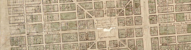
James Doty’s plat, showing Capitol Square. Wisconsin Historical Society
To accomplish this meeting, the grid makes a bend as it approaches the isthmus from the west, and the city’s main east-west thoroughfares become by this transformation northeast-southwest thoroughfares. This subtle turn can be almost imperceptible to a first-time visitor, and upon arriving in the city I found myself for some time baffled by how disoriented I could get on account of this innocuous little bend. Below is a map showing the approximate location of this great source of confusion:
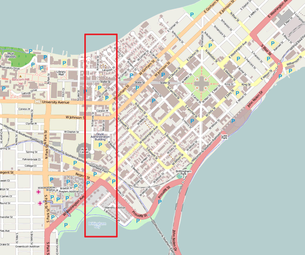
Thinking about the isthmus this way, like an forearm cocked slightly upwards at the elbow, made me wonder what Madison might look like unbent. What would happen if we put the entire city through some kind of titanic clothes-press, bringing its crooked thoroughfares back into straightness? And so, as I had no choice but to do, I made a map:
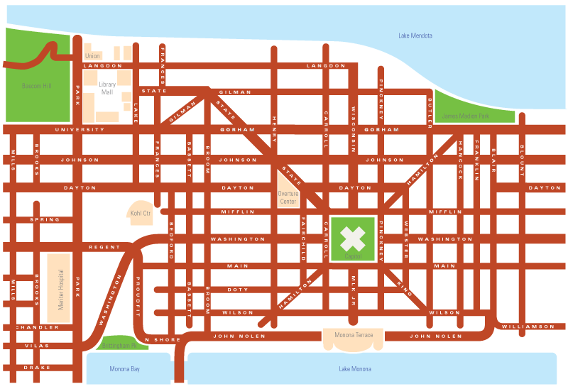
This rather hastily thrown-together piece of cartography shows a straightened-out Madison. The main thoroughfares—Johnson and Gorham Streets—now maintain their alignment as they enter the isthmus. The shores of Lakes Mendota and Monona now fit into a Cartesian ideal, providing no stubborn challenge to the surveyor’s grid. This unbending, of course, has not come without any victims: notice, most startlingly, State Street, which in reality cuts a swath east-west across the isthmus, and must now find itself subject to a jarring bend. The blocks of the Bassett neighborhood have been shrunk down drastically to accommodate the imperious rotation of the isthmus downwards. And West Washington Avenue, like the bellows of an accordion, now finds its extra length folded up upon itself in the close of the hinge. Similarly, Brittingham Park has been squeezed down into a tiny wedge.
In a certain sense, this map—which is topologically accurate but topographically distorted, is actually easier to use for navigating the isthmus than a standard one. It shows the essential connectedness of the two grids by forcing them into a consistency with each other. It tyrannically asserts the logical supremacy of the rectangle over the vicissitudinous earth left by the glacier. I think Jefferson (and perhaps Doty) would be proud.
 http://viewshed.matinic.us/2012/02/23/321/