

The tragic shooting of Michael Brown in Ferguson, and the subsequent unrest between protestors and police, have put urban race relations at the center of national debate. Many commentators have pointed out that the incident is just one extraordinary example of the all-too-ordinary reality of the structural discrimination against blacks that lingers on decades after the victories of the civil rights movement. Ferguson, like so many similar places across the country, is the kind of town that shows how segregation occurs even without explicit legal sanction, through economic exclusion and racial-cultural self-sorting.
One thing that should give a geographer or a political scientist a moment of pause, however, is the way that the coverage of the incident tends to describe the site of the problem with such territorial imprecision. Sometimes it is Ferguson that we are talking about; then, without notice of the switch, it is St. Louis, or St. Louis County. So where, exactly, are we talking about? Is the Michael Brown tragedy—and the associated pattern of racial segregation that produced it—a Ferguson problem? A Greater St. Louis problem? A Missouri problem? An American problem—or even a global one?
This scale question might sound like a cartoon of academic geography. But the basic logic of how we statistically measure segregation demands that we find an answer to it. Segregation, after all, is a measure of how territorially well-sorted people are according to some sort of demographic quality—race, in this case. In order to measure that sorting, we have to draw unit territories and then count how many people of each race live in them. In statistical geography, this is called binning or aggregating, and it gives rise to something known as the modifiable areal unit problem.
The modifiable areal unit problem occurs because the territories which we use to aggregate spatially-distributed phenomena are inherently arbitrary. These units don't exist preformed in the world; we make them up. And the choices we make when drawing these units can radically change the statistical outcome of measures such as segregation.
Here's a simplified example to show how this problem manifests itself. Let's imagine Division City, with 50 people, 30 white and 20 black, who live in the following arrangement:

How can we measure if this city is segregated? With just a single territorial unit, we have no way of capturing this statistic, for all we have is a single fraction: 60% white, 40% black. So we need to subdivide Division City into units, and then see how those units compare to the racial distribution of the city at large. But how? Perhaps we might choose to divide the city up into “neighborhoods,” units which have no political standing but which have emerged in cultural consciousness following the recognition of a shared cultural or typological identity. Let’s say our fictitious town has three neighborhoods, Whiting, King Heights, and Bronzeville, divided like so:

Taken from this perpsective, Division City is segregated indeed, and obviously so: we find one neighborhood that is almost entirely black, one that is almost entirely white, and one that is entirely white.
But perhaps choosing neighborhoods has set us up for a foregone conclusion: if the neighborhood boundaries of Bronzeville are intuitively defined by the areas where black families live, then of course Bronzeville will have a higher black population than average. So how else could we partition the city for statistical purposes? What if our city was divided long ago into gridded wards for municipal elections, the borders of which still exist today, like this:
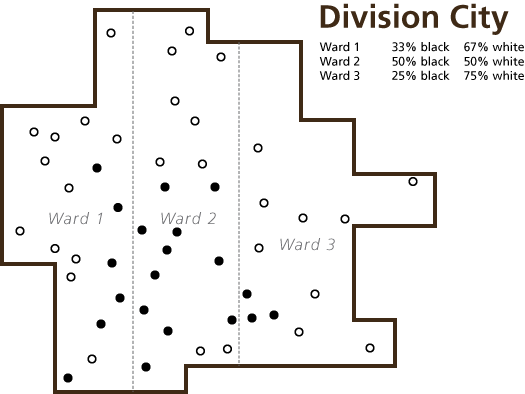
All of a sudden Division City's racial segregation problem seems to have receded, even though nobody has moved. Or what if we divided our city neatly geographically into four quadrants, like this:

Again, we find a very different measure of segregation. This coldly geographical partitioning of Division City, however, suggests just how arbitrary this unit-making process can be. Consider these two families: perhaps they are two members of the extended family, who have chosen to live close together: of course their proximity to each other makes them feel like they live in the “same” place. But the statistical boundary which we have wedged between them means that one family counts towards the northeastern aggregation unit, while the other counts towards the southeast unit.

At the Washington Post, Jonathan Redden point out that the level of segregation in St. Louis and in Ferguson changes depending on how you draw these aggregation units. Measured from a metropolitan perspective divided into block-level tracts, the St. Louis metropolitan area is amongst the nation’s most strikingly segregated. The city of Ferguson itself, however, is remarkably integrated when measured at the same block-level specificity: a conclusion quite contrary to expectations. Again, though, this is based on the statistician’s choice to label “Ferguson” itself as a unit. Perhaps the black families living on Ferguson’s southeast side feel belonging more to a single community with the residents of neighboring Canfield Green area than they do with the largely-white central area of Ferguson.
The way we draw the borders of our units, then, has serious consequences on whether or not we can statistically “see” segregation taking place. It also has even more significant consequences for political representation and the provisioning of municipal services. Ferguson is an economic and cultural vassal of the St. Louis metropolis. But it is not part of St. Louis, and the political clout which blacks in St. Louis proper have spent painstaking decades to build holds no sway across the municipal boundary. Jeff Smith, a professor of urban policy at the New School writes in the New York Times that the strangling of St. Louis’s municipal power inside of a tightly-drawn municipal boundary is one of the reasons why places like Ferguson have become the locus of such tense racial politics. He suggests that consolidating the municipality into a single entity could be one way of redistributing political power more equitably:
But there’s a potential solution that could help Ferguson reinvest in itself and also help African-Americans compete for a bigger share of the pie: consolidation with surrounding municipalities, many of which face similar challenges. The St. Louis region has seen some preliminary support for the idea, with resistance concentrated in smaller political units whose leaders are loath to surrender control.
This tension between municipal cores and their independent suburbs is perhaps the most important geographic struggle of the past century of American history, and it has major consequences for both the allocation of political power and the physical growth and decay of neighborhoods which is a consequence of that allocation. Suburbs allow for what we might call geographic arbitrage: they create spaces which are economically and ecologically integrated into the urban core, but which retain political, cultural, and social autonomy. The border between city and suburb thus becomes selectively porous one, through which capital can flow but votes cannot.
Frank Zeidler, the Socialist mayor of Milwaukee from 1948 to 1960, foresaw how the sprawl of white suburbs beyond the municipal borders was to doom the black and immigrant communities of Milwaukee proper to economic and political marginality. Bitterly opposed to the political independence of Milwaukee’s fringes, he went so far to say of the suburbs that “we do not believe they have reason for existing.”
Do they have reason for existing? It is a question which we do not ask ourselves often enough. Is there a single St. Louis and a single Ferguson, or do they blur into each other so completely that measuring—and governing—them separately is nonsensical? The way we answer that question is not only a statistical problem: it is also a crucial one to answer if we are to decide how to distribute political power, public services, and community self-determination amongst the people of a sprawling metropolis.
 http://viewshed.matinic.us/2014/09/09/738/